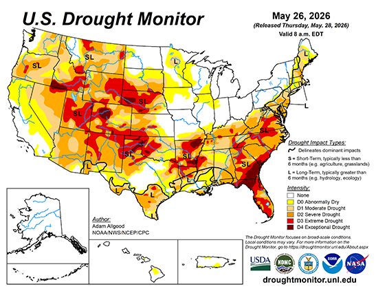
During the upcoming week, a late season storm system across the West is forecast to bring abnormal moisture to California, Oregon, and Washington, with precipitation spreading eastward to the northern Rockies by mid-week. The heaviest accumulations are forecast across the southern Cascades. Periods of convection are favored across the Plains states throughout the week, with the WPC 7-day quantitative precipitation outlook showing a potential for 1 inch or locally more across portions of Nebraska and Kansas, where Gulf moisture advection is most pronounced. Across the eastern third of the CONUS, unsettled weather is favored to continue across the Southeast, with the focus of heaviest precipitation shifting towards Florida and the south Atlantic coastal plain. A slow moving cold front is forecast to push east during the period, maintaining showery weather across the Deep South while cooler and drier conditions overspread the Corn Belt and Northeast.
During Week-2, the trough over the East is favored to rapidly de-amplify, with temperatures quickly moderating. Above-normal temperatures are favored across the West and northern tier of the CONUS on the latest CPC 8-14 day outlook, with mostly near-normal temperatures the most likely outcome across the South and Southeast regions. Unsettled weather and continued precipitation may play a role in keeping hot weather at bay across the southern tier. The CPC 8-14 day precipitation outlook favors above-normal precipitation across the Four Corners states eastward along the southern tier to the Atlantic coastline as far north as Virginia. Near normal precipitation is favored elsewhere, except for a small wet signal over the Pacific Northwest. Above-normal precipitation is favored for eastern Alaska, while above-normal temperatures and above-normal precipitation are both favored for Hawaii.