National Current Conditions...

November 12, 2025 - November 18, 2025

This past week, drought worsened in the Southern Plains and Southeast. Exceptional Drought (D4) was introduced to the Florida/Georgia border. Meanwhile, drought improved in the far West, particularly Washington and California. As of November 18, 2025, 38.65% of the U.S. and Puerto Rico and 46.12% of the lower 48 states are in drought, according to the U.S. Drought Monitor.

This Week's Drought Summary…

Dry weather covered most of the central and eastern U.S. this week, with a few localized areas of heavier precipitation falling in the Northeast and parts of eastern South Dakota. In the West, heavy rain and snow was widespread, especially in parts of southern Nevada, southern and coastal California, the Sierra Nevada, the Pacific Northwest and northwest Montana. Temperatures west of the Mississippi River were mostly warmer than normal, especially in Montana and Wyoming, where temperatures of 12 or more degrees above normal were common. East of the Mississippi River, near- or below-normal temperatures were widespread, especially in southern Georgia and Florida, where temperatures were 6-12 degrees colder than normal. Given the wetter weather recently, improvements continued in parts of the Northeast, where streamflow and soil moisture continued to recover and precipitation deficits lessened. Improvements were also widespread in California and Washington, where recent precipitation has cut into or erased precipitation deficits and boosted soil moisture and streamflow. Degradations were common in Oklahoma, Texas, Louisiana, Florida, Georgia and North Carolina, where short-term precipitation deficits grew. Widespread degradation also occurred in parts of Nebraska, central and northeast Montana and the western Great Lakes area, as primarily short-term dryness intensified in each of these areas. Recent pockets of drier- or wetter-than-normal weather led to a few small changes in areas of abnormal dryness in Puerto Rico. Wetter weather in the windward sides of Hawaii led to local improvements on Oahu, Maui and the Big Island, where streamflows have responded well to increased precipitation.


Looking Ahead...

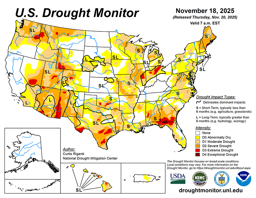
From the evening of Nov. 19 through Nov. 24, the National Weather Service Weather (NWS) Prediction Center is forecasting a large area to receive near or over 1 inch of precipitation from southern Ohio eastward to northeast Colorado and south to northwest Louisiana and much of Oklahoma and Texas (excluding the southwest). Precipitation amounts of at least 0.75 inches are also forecast in parts of southern California, southern Arizona and southeast two-thirds of New Mexico. Heavy precipitation, locally exceeding 3 inches, is forecast in parts of western Washington. Mostly dry weather is forecast across the northern Great Plains and from the Upper Midwest eastward to most of New York and northern New England. Dry weather is also likely to continue in much of the Southeast, especially in drought-stricken areas of southeast Louisiana, southern Georgia and Florida.
For Nov. 25-29, the forecast favors above-normal precipitation across parts of the northern, central and eastern U.S. The highest confidence areas for above-normal precipitation include the northern Great Plains and the Southeast. Drier-than-normal weather is favored in the Southwest U.S., especially in coastal California, southeast Arizona, southern New Mexico and southwest Texas. The forecast favors colder-than-normal temperatures from northern Washington east to Lake Superior and southward through the central Great Plains. In the West, warmer-than-normal temperatures are likelier from central Oregon southward along the Pacific Coast and eastward to near the Continental Divide. The forecast favors warmer-than-normal temperatures in areas from the Gulf Coast to the Mid-Atlantic, with the highest confidence for warmth centered over the Southeast.