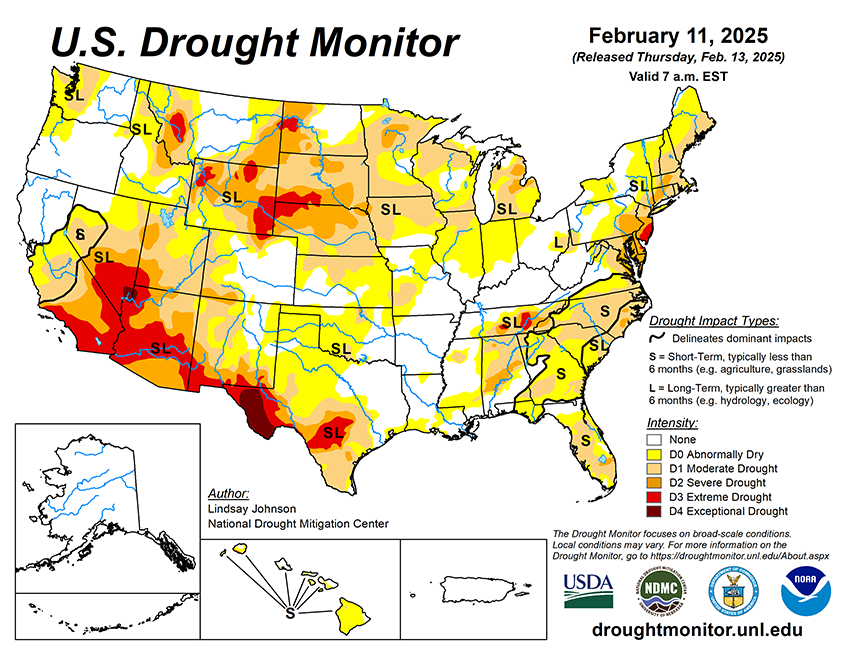

National Current Conditions: February 5, 2025 - February 11, 2025
For the fifth week in a row, drought worsened in the Southwest. Parts of the Northwest, Midwest, and Southern Plains across to the Southeast degraded too. Meanwhile, parts of the Northern Rockies and Mid-Atlantic improved.
As of February 11, 2025, 36.46% of the U.S. and Puerto Rico and 46.63% of the lower 48 states are in drought, according to the U.S. Drought Monitor.

This Week's Drought Summary…
Conditions this week were largely based on where precipitation fell. Storms across the Ohio River Valley and Mid-Atlantic brought very beneficial rainfall, leading to improvements in eastern Oklahoma, northeast Mississippi, northern Alabama, the Tennessee-North Carolina border, Virginia and northern West Virginia. Outside of this band of precipitation in the center and eastern U.S., conditions continued to deteriorate after weeks of little to no precipitation. Many of the coastal states in the Southeast saw widespread degradation as short-term indicators show deteriorating conditions. High temperatures in many of these areas make conditions worse. Snow in the Northern Rockies and central Montana brought improvements but the rest of the West was not so lucky. Precipitation along coastal mountains kept conditions in Oregon and California unchanged, Nevada and the four-corners region saw conditions continue to deteriorate. Areas of higher elevation are seeing low snowpack for this time of year. Hawaii also saw conditions improve, while Alaska and Puerto Rico remain free of any dry or drought conditions.
Looking Ahead...
Over the next five to seven days, some coastal areas of the West could see precipitation from the Washington Cascades into most of California. Other higher-elevation areas in the Intermountain West as well as in the Southwest, are also expected to receive some precipitation. Heavy precipitation is expected across the South, Southeast and Northeast where amounts are estimated to reach 1.25 to 5 inches in the lower Ohio River Valley and through Alabama. Once again, much of the Plains, from North Dakota through central-west Texas, are expected to see less than a quarter of an inch of precipitation.
The 6-10 day outlook shows the greatest probability of below-normal temperatures are in the central Midwest. Below-normal temperatures are expected to be below-normal from central Montana to central Texas and all the way into Maine. The best chances of above-normal temperatures will likely be across Alaska and Hawaii. Southern Arizona and southern Florida are expected to stay near normal temperatures. The greatest chances of above-normal precipitation are expected to be across the Gulf Coast from Texas and across the Florida Peninsula. A large swath of the country (Washington towards the Gulf of Mexico) is leaning towards above-normal precipitation. Alaska is also leaning toward above-normal precipitation. Along California’s central and southern coast precipitation are expected to be drier –than normal, and to a lesser extent, Arizona, Nevada, and southwest New Mexico. The northern Midwest and Great Lakes region, along with Hawaii, are expected to have near or just below normal precipitation.


