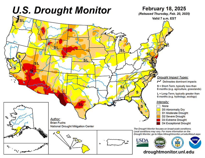

National Current Conditions: February 12, 2025 - February 18, 2025
For the sixth week in a row, drought worsened in the Southwest, although less than in previous weeks, with a few areas of improvements. Large parts of California, the South/Southeast, and Mid-Atlantic improved.
As of February 18, 2025, 33.41% of the U.S. and Puerto Rico and 39.97% of the lower 48 states are in drought, according to the U.S. Drought Monitor.

This Week's Drought Summary…
A significant storm system moved through the South and into the Southeast during the week, which was associated with flooding rains over the Tennessee Valley and into Kentucky where some of these areas recorded 7-8 inches of rain or more. Portions of northwest Tennessee had CoCoRaHS reports of over 10 inches of rain over the previous week, with the greatest amount of 11.35 inches outside of Clarksville, TN. Many reports of 3 or more inches of rain were observed from northern Louisiana up to southern Virginia with pockets of northern South Carolina with widespread 6+ inches of rain recorded. With recent dryness and a prolonged rain event, many areas had good infiltration into the soil and even some runoff which helped the local hydrological conditions. The Northern and Southern Plains were mostly dry, with areas of east Texas seeing some benefits of rain. Rain returned to the lower elevations of California and up the West Coast as well as snow in the upper elevations in the West. Temperatures were colder than normal over most of the country, with the greatest departures over Montana and North Dakota where temperatures were greater than 25 degrees below normal. The warmest areas this week were in the Southwest and Southeast, where temperatures were near normal in the Southwest and 5-10 degrees above normal in Florida and southern Georgia..
Looking Ahead...
Over the next five to seven days, it is anticipated much of the area in the Southeast and into portions of the South will see additional precipitation with some areas that missed out on the last event potentially recording up to an inch of precipitation with this next storm system. Areas along the East Coast also are anticipated to see additional precipitation while much of the Pacific Northwest and into the northern Rocky Mountains is anticipated to see additional precipitation during this period. Much of the Plains, Midwest and Southwest are anticipated to be dry. In a reversal of recent weeks, warmer-than-normal temperatures are expected over much of the area from the Plains westward with departures of 13-16 degrees above normal over much of the Southwest. The areas east of the Plains are anticipated to be near normal.
The 6-10 day outlooks show the high probability of warmer-than-normal temperatures over the western half of the country, with the best probability of above-normal temperatures over the Southwest and portions of the High Plains. The greatest chances of below-normal temperatures will be over Florida. The greatest probability of above-normal precipitation will be along the Canadian border with the best chances of above-normal precipitation in portions of the High Plains, Midwest and New England. Above-normal chances of below-normal precipitation will be over much of the West, southern Rocky Mountains and southern Plains.


