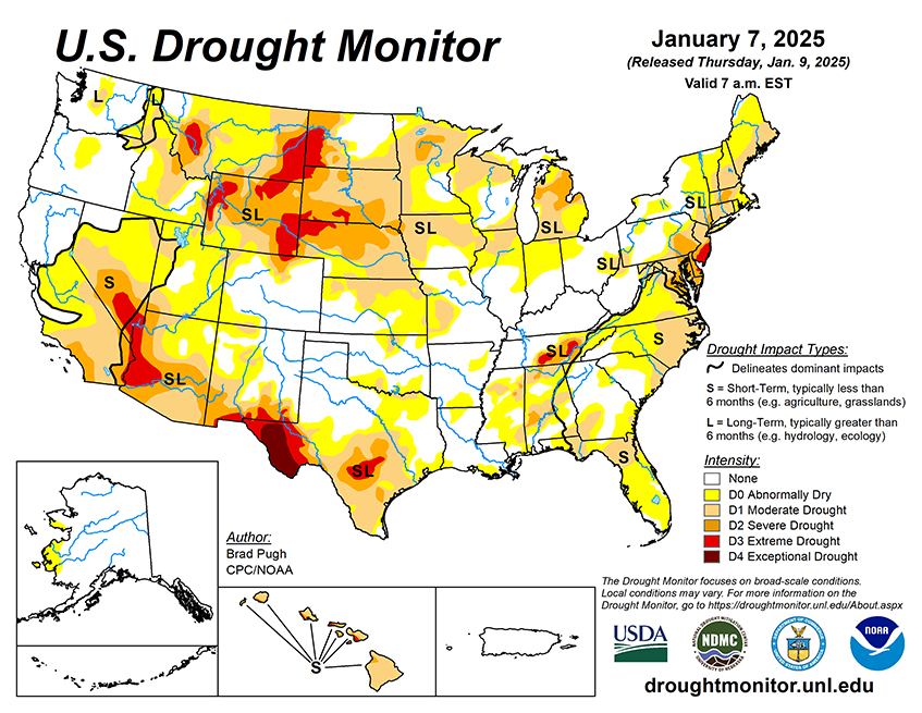
National Current Conditions: January 1, 2025 - January 7, 2025
In general, this week brought improvements in drought and dryness in the northern U.S. and degradations in the southern U.S. There were exceptions: an area from eastern Texas across to Alabama improved.
As of January 7, 2025, 30.86% of the U.S. and Puerto Rico and 36.72% of the lower 48 states are in drought, according to the U.S. Drought Monitor.
This Week's Drought Summary…
On January 4 and 5, a low pressure system developed across the Central Great Plains and then tracked eastward to the Mid-Atlantic. Along its track, widespread precipitation (1 to 2 inches, liquid equivalent) was observed throughout eastern Kansas, Missouri, the Ohio and Tennessee Valleys, Central Appalachians, and Mid-Atlantic. Total snowfall amounts were near or more than a foot in portions of these areas. This winter storm also resulted in freezing rain for the Ohio Valley and parts of Virginia and West Virginia. Drought improvements were generally made to portions of the central and eastern U.S. where precipitation amounts exceeded 1 or 1.5 inches, liquid equivalent.
Drought coverage and intensity continued its decline for the Upper Ohio Valley and New England. After the winter storm exited the East Coast, an arctic air outbreak overspread the eastern two-thirds of the lower 48 states. A favorable start to the wet season coupled with above-normal snowpack supported a decrease in drought coverage across the Pacific Northwest. Conversely, drought worsened for southern California and the Southwest. Alaska and Puerto Rico remained drought-free, while short-term drought intensified across Hawaii.
Looking Ahead...
A low pressure system is forecast to develop along the western Gulf Coast by January 10 with a rapid eastward track offshore of the Mid-Atlantic one day later. A large area of 1 to 2.5 inches of rainfall is expected for eastern Texas and the Lower Mississippi Valley, while accumulating snow occurs from the southern Plains east to the Tennessee Valley and Southern Appalachians. High elevation snow is forecast to shift east from the Cascades to the northern Rockies on January 10 and 11. Farther south across California, dry weather is likely to persist through mid-January. On January 13, another Arctic high is forecast to shift south from Canada to the Great Plains.
The 6-10 day outlook (valid January 14-18, 2025) favors below-normal temperatures for a majority of the lower 48 states. The largest below-normal temperature probabilities (exceeding 80 percent) are forecast for the Southeast. An increased chance of above-normal temperatures is limited to the Dakotas and Minnesota. Below-normal precipitation is most likely across the Pacific Northwest, Great Basin, and much of California. Elevated above-normal precipitation probabilities are forecast for the Southwest, Texas, and High Plains, while below-normal precipitation is slightly favored along the East Coast.


