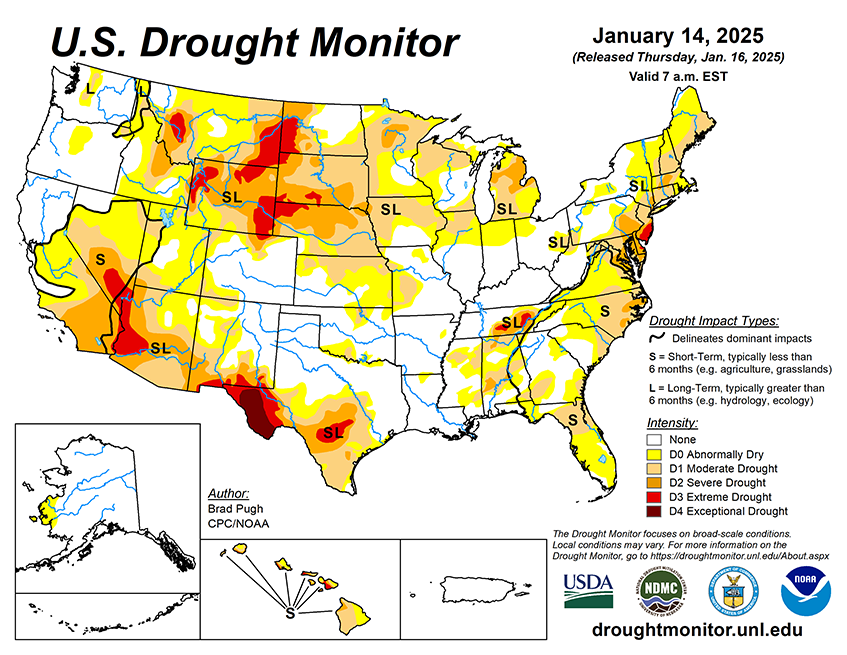
National Current Conditions: January 8, 2025 - January 14, 2025
Drought worsened in central Texas, the Southwest, and southern California. Most of southern California is in Severe Drought (D2), including where the wildfires are burning. This week brought improvements to parts of eastern Texas, the South/Southeast, and the Midwest.
As of January 14, 2025, 30.8% of the U.S. and Puerto Rico and 36.7% of the lower 48 states are in drought, according to the U.S. Drought Monitor.
This Week's Drought Summary…
On January 9 and 10, a low pressure system tracked along the Gulf Coast and resulted in widespread precipitation (1 to 2.5 inches, liquid equivalent) from eastern Texas and the Lower Mississippi Valley east to the Florida Panhandle. On the northern extent of this storm, snow blanketed areas from Oklahoma and Arkansas to north Georgia. This precipitation during the second week of January supported drought improvement. However, drought expanded and intensified for the Florida Peninsula, eastern North Carolina, west-central Texas, and the Southwest.
During the first two weeks of January, multiple Arctic surface highs shifted south from Canada and temperatures (January 1-13) averaged 4 to 8 degrees F below normal for much of the Great Plains, Middle to Lower Mississippi Valley, and Southeast. A very dry start to the wet season continued to affect southern California with worsening drought conditions, periodic Santa Ana winds, and large wildfires. Enhanced trade winds, typical during a La Niña winter, resulted in improving drought for the windward side of the Hawaiian Islands.
Looking Ahead...
Another Arctic air outbreak is forecast for the central and eastern U.S. during mid-January as surface high pressure shifts south from Canada. By January 20, subzero minimum temperatures are expected as far south as the Central Great Plains, Middle Mississippi Valley, and Ohio Valley. During January 16-20, little to no precipitation is forecast from the West Coast to the Mississippi Valley with light to moderate precipitation amounts (0.5 to 1 inch) limited to the Southeast. These amounts, however, have been sufficient for rainfall to almost keep up with demand, and the near-normal amounts the past 2 weeks have kept the area out of D0 conditions for the time being, but the situation needs to be closely monitored for signs of increasing dryness impacts. Daily rainfall reports are not available for Mili since the start of January 2025, but 45.59” fell during October-December 2024, above the normal of 36.55” and well above the amount needed to keep up with demand, which is sufficient to keep D0 conditions at bay regardless the rainfall during the past 2 weeks.
The Climate Prediction Center’s 6-10 day outlook (valid January 21-25, 2025) favors below-normal temperatures to persist for much of the contiguous U.S. with the largest below-normal temperature probabilities (exceeding 80 percent) extending from the Mid-Atlantic and Ohio Valley south to the Gulf Coast. Elevated above-normal precipitation probabilities are forecast for the northern Great Plains, Gulf Coast, and portions of the Southeast. Below-normal precipitation is favored for the West, Central Great Plains, Midwest, and New England.


