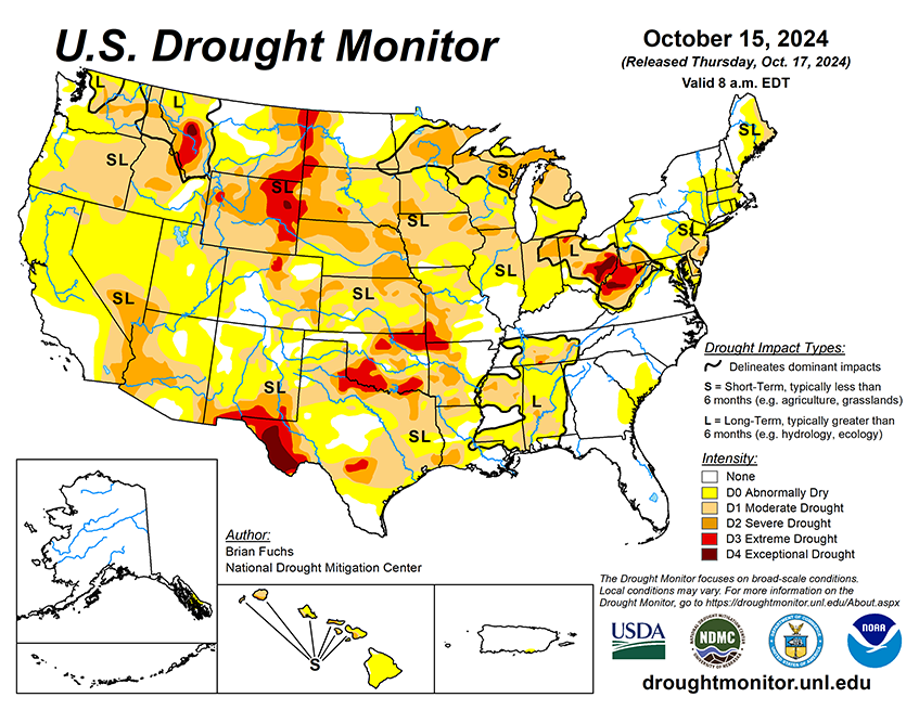

National Current Conditions: October 9, 2024 - October 15, 2024
The U.S. saw a huge expansion of drought for the second week in a row. Every state in the Plains and Midwest worsened except Kentucky. Parts of the West, South/Southeast, Northeast, and Hawaii worsened too.
As of October 15, 2024, 37.65% of the U.S. and Puerto Rico and 45.02% of the lower 48 states are in drought, according to the U.S. Drought Monitor.
This Week's Drought Summary…
Precipitation across the country was pretty much nonexistent over the past week. The outliers were in Florida as Hurricane Milton came ashore and brought with it copious amounts of rain over much of the peninsula, as well as some rains in the upper Midwest into New England, and some coastal areas of the Pacific Northwest. From the Mississippi River west, most areas were warmer than normal, with departures of 9-12 degrees or more above normal over much of the southern Plains, Rocky Mountains, and into the desert Southwest. Cooler-than-normal temperatures were recorded along the Eastern Seaboard with departures of 3-6 degrees below normal quite common.

Looking Ahead...
Over the next 5-7 days, it is anticipated that much of the Rocky Mountain and central Plains areas will have the best chances for measurable precipitation. The highest amounts are anticipated over northeast New Mexico, southeast Colorado, and parts of the Oklahoma and Texas panhandles, where 2 or more inches may be recorded. Most of the other areas are expecting an inch or less. Temperatures during this time are anticipated to be above normal over much of the Plains, Midwest, and into the Northeast, with departures of 10-15 degrees above normal over the upper Midwest. Cooler than normal temperatures of 2-4 degrees below normal are expected over the Four Corners region and the Rocky Mountains.
The 6-10 day outlooks show that above-normal temperatures will continue for almost all of the country through the end of October, especially from Texas into the Midwest. The coastal areas of the Pacific Northwest have the greatest probabilities of below-normal temperatures during this time. Outlooks show that the greatest chances of below-normal precipitation are from the Gulf Coast into the Midwest and over much of the East. The highest probabilities of above-normal precipitation will be in the central to northern Plains, northern Rocky Mountains and into portions of the Pacific Northwest.


