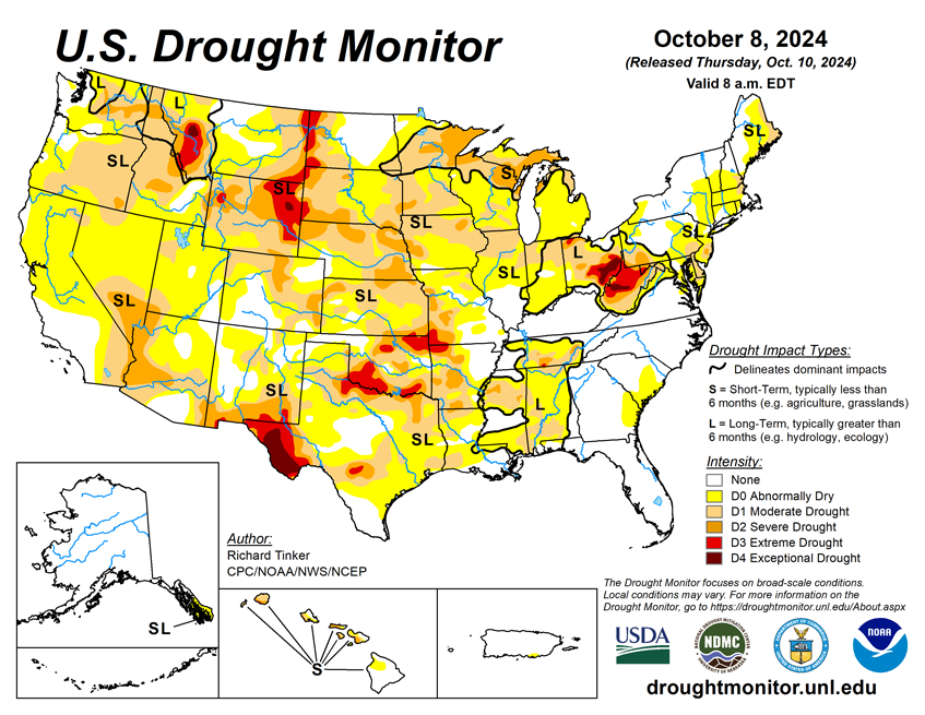

National Current Conditions: October 2, 2024 - October 8, 2024
Weeks of warm temperatures (with some record heat) and little to no precipitation have led to dryness and drought worsening in every state in the Southwest, Northern Rockies, Plains, South, and Upper Midwest.
As of October 8, 2024, 32.61% of the U.S. and Puerto Rico and 38.98% of the lower 48 states are in drought, according to the U.S. Drought Monitor.
This Week's Drought Summary…
After the intense rains from Hurricane Helene tapered off, this past week was extremely dry over a large majority of the contiguous 48 states. Rainfall totals exceeding 2 inches were limited to much of the Florida Peninsula, the immediate central Gulf Coast, the Louisiana Bayou, and Deep South Texas. Several small, isolated locations across these areas reported as much as 5 inches of rain. Significant rainfall was hard to find in other areas. Several tenths of an inch, with isolated totals up to 1.5 inches, fell on Maine, southeastern New England, the central Appalachians and foothills, southeastern Virginia, the Upper Peninsula of Michigan, southeastern Iowa, west-central Illinois, and the Pacific Northwest from the Washington and northern Oregon Cascades to the Pacific Coast.
The remainder of the country recorded at most 0.25 inch of precipitation, with a vast majority of the area measuring no precipitation for the week. This abetted recovery in places devastated by the intense rains and flooding associated with Hurricane Helene, but also caused dryness and drought to persist or intensify. Rapid deterioration was starting to take place in parts of the Lower Mississippi Valley and southern Great Plains while deterioration proceeded at a slower pace in other parts of the Nation affected by dryness and drought. In addition, unseasonably high temperatures accentuated the dryness in many areas, particularly in the Southwest.

Looking Ahead...
During the next five days (October 10 - 14), Hurricane Milton will contribute to excessive rainfall across much of the central and northern Florida Peninsula, but most other parts of the Nation should expect little precipitation, if any. Between 10 and 15 inches of rain are expected in part of the northeastern Florida Peninsula, and totals of at least 5 inches are expected from St. Petersburg and Cedar Key northward to the Florida Big Bend and the south side of Jacksonville. To the north and south of this band, precipitation totals will be considerably lower. Near or less than an inch is expected over most of the southern Florida Peninsula. Farther north, there will be a tight gradient between heavy rain and little or none, with totals over 0.25 inch no farther north than just north and west of the Florida Big Bend through extreme southeastern Georgia. Elsewhere, a frontal system is expected to drop 0.5 to 1.0 inch of rain from the northern and eastern Great Lakes through northwest Pennsylvania, upstate New York, and central and northern New England. Light to locally moderate totals (0.1 to 0.5 inch) are forecast aross the Upper Ohio Valley and southern New England, and across northwestern California from San Francisco to the Oregon border. Little or no precipitation is expected across the remainder of the contiguous U.S., including most areas impacted by dryness and drought. Near or slightly less than normal precipitation is expected in far southeastern Alaska. Meanwhile, temperatures are anticipated to be above normal from most of Texas and the High Plains westward to the Pacific Coast. Daily maximum temperatures are forecast to average 10 to 16 deg. F above normal across the northern halves of the Rockies and Intermountain West. In contrast, most locations east of the Mississippi River are expected to average cooler than normal, with highs averaging 4 to 6 deg. F below normal through most of the Appalachians, eastern Great Lakes, and New England.
The 6-10 day outlook (valid October 15 - 19) favors above normal precipitation for the Florida Peninsula and the immediate South Atlantic Coast, with chances for significantly above normal rainfall exceeding 50 percent in southern Florida. Enhanced chances for wetter than normal weather also cover the Pacific Northwest and northern Intermountain West. Meanwhile, subnormal precipitation is favored from the central Gulf Coast, Southeast Piedmont, and interior mid-Atlantic and Northeast westward through the Plains and into the central Rockies and eastern Great Basin. Significantly drier than normal weather is at least 50 percent likely from the Great Lakes southward through most of the Tennessee and lower Mississippi Valleys. Warm weather is favored from the northern Great Lakes, central Great Plains, and southern High Plains westward to the Pacific Coast. Chances for unusually warm weather exceed 70 percent in the northern High Plains and the northern half of the Rockies. Farther east, lower than normal temperatures are expected from the southeastern Great Lakes, middle and lower Mississippi Valley, and southeastern Great Plains eastward through the Atlantic Seaboard. The likelihood of subnormal temperatures exceeds 70 percent across most of the Carolinas, southwestern Virginia, the southern Appalachians, and most of Georgia and Alabama. Odds somewhat favor relatively cool conditions and near normal precipitation in southeastern Alaska while near-normal precipitation is expected to be accompanied by warmer than normal conditions across Hawaii.


